


New Routes

Po Kwu Wan,
Pai Tau TunView : 
Difficulty : 
Path : Pak Tam Chung ➡ Sheung Yiu ➡ Hei Tsz Wan ➡ Po Kwu Wan ➡ Sheung Yiu… Length : 6.8 km Time : 4 hours Po Kwu Wan is located in a bay on the west side of Sai Kung Pak Tam Chung High Island Reservoir and Pai Tau Tun. Its vil…
Total Views: 92,418
Po Kwu Wan
View : Difficulty : 
Path : Pak Tam Chung ➡ Sheung Yiu ➡ Hei Tsz Wan ➡ Po Kwu Wan ➡ Sheung Yiu… Length : 7.6 km Time : 2½ hours Po Kwu Wan is located in the northwest of Sai Kung Pak Tam Chung High Island Reservoir. There used to be a village, but …
Total Views: 89,387
Tseung Kwan O Lunar New Year Horse
View : 
Difficulty : 
Path : Tiu Keng Leng Station ➡ Hong Kong Velodrome ➡ Tseung Kwan O Centre… Length : 11.9 km Time : 2½ hours This route, themed 'Good Fortune in the Year of the Horse', will trace a small horse pattern in Tseung Kwan O, covering …
Total Views: 19,844
Miu Tsai Tun,
High Junk Peak,
Tin Ha ShanView : Difficulty : 
Path : Ng Fai Tin ➡ Sheung Yeung Shan ➡ Ha Yeung Shan ➡ Miu Tsai Tun ➡ Hi… Length : 6.8 km Time : 5 hours Sheung Yeung Shan, Ha Yeung Shan, Miu Tsai Tun, High Junk Peak, and Tin Ha Shan are all located on the Sai Kung Clear Wa…
Total Views: 9,858
Tin Ha Shan
View : Difficulty : 
Path : Ng Fai Tin ➡ Sheung Yeung Shan ➡ Ha Yeung Shan ➡ Miu Tsai Tun Moun… Length : 6.6 km Time : 3½ hours Tin Ha Shan is located on the Clear Water Bay Peninsula in Sai Kung, with an elevation of 274 meters. It belongs to the …
Total Views: 12,385
Lin Fa Shan,
Shek Lung Kung,
Ha Fa ShanView : 
Difficulty : Path : Route Twisk ➡ MacLehose Trail (Section 9) ➡ Pat Heung Fire Lookout… Length : 9 km Time : 4½ hours Lin Fa Shan, Shek Lung Kung, and Ha Fa Shan are all located in the mountains south of MacLehose (Section 9) and northwes…
Total Views: 145,951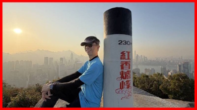
Hung Heung Lo Fung
View : Difficulty : 
Path : Tai Hang Lin Fa Kung Temple ➡ Lai Tak Tsuen ➡ Ma Shan Tsuen ➡ Hung… Length : 1.9 km Time : ¾ hours Hung Heung Lo Fung, at an altitude of 230 meters, is near Braemar Hill on Hong Kong Island. It's very close to the city …
Total Views: 7,762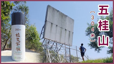
Black Hill,
Wai Kap Shek LengView : Difficulty : 
Path : Lei Yue Mun Estate ➡ Lingnan Template ➡ O King Road ➡ Wilson Trail… Length : 7.5 km Time : 2½ hours Black Hill, also known as Black Ghost Mountain and Five Ghost Mountain. The Black Hill Main Peak is 304 meters high, and…
Total Views: 95,953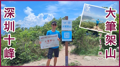
Shenzhen Ten Peaks Dabijiashan
View : Difficulty : Path : Baishawan Park ➡ Sanganbi ➡ Hankeng Rest Area ➡ Dabijiashan ➡ Hank… Length : 8.2 km Time : 5½ hours Shenzhen Dabijiashan is 717 meters above sea level. It is located in Baguang, east of Shenzhen, at the junction of Shenz…
Total Views: 21,613
For length of days, and long life, and peace, shall they add to thee.
Proverbs 3:2
Hot Routes (Last 7 days)
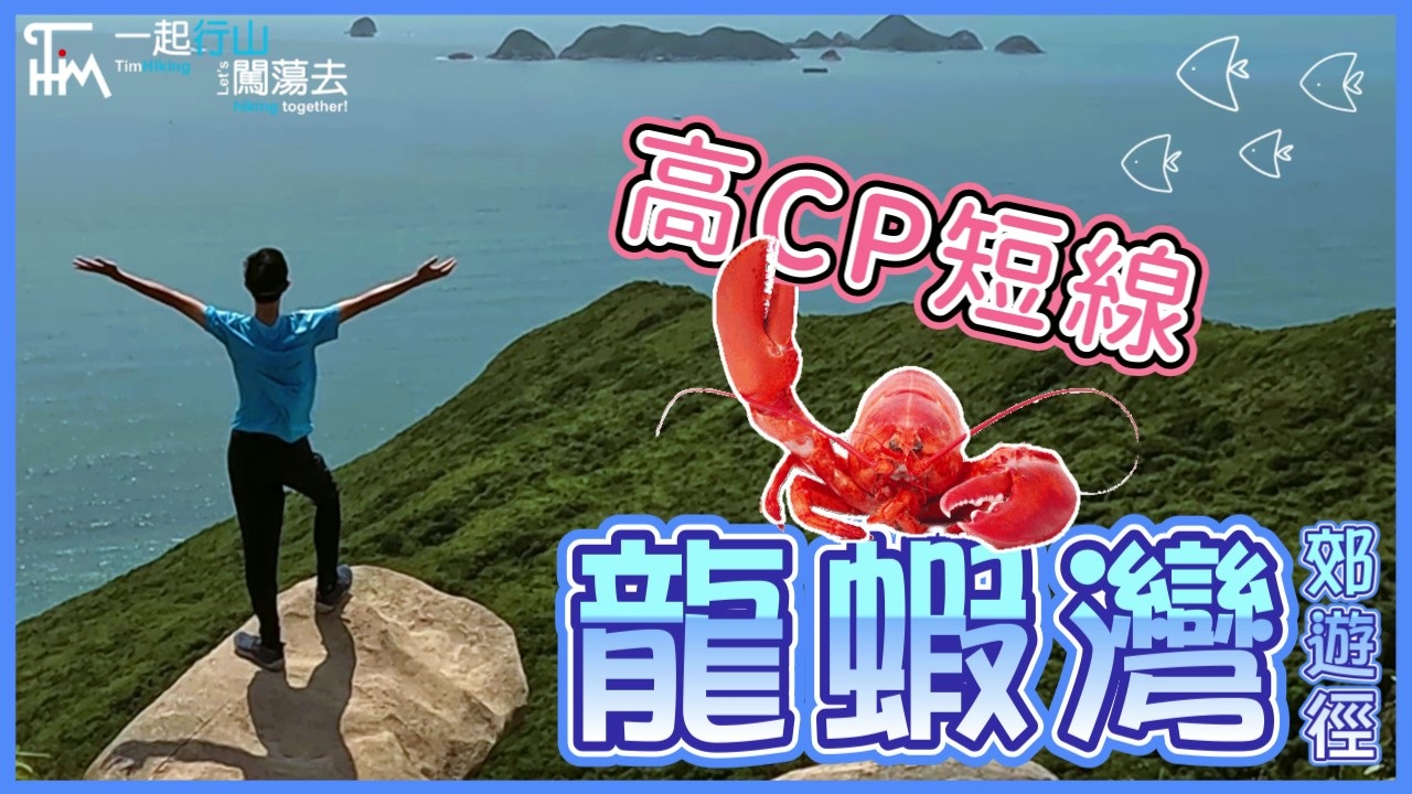
Lung Ha Wan Country Trail
View : 
Difficulty : Path : Tai Au Mun ➡ Tai Hang Tun ➡ Tai Leng Tung ➡ Ping Tok Hang Shan ➡ L… Length : 2.4 km Time : 2.5 hours Lung Ha Wan Country Trail is located in Tai Au Mun, starting near Tai Au Mun Barbecue Area and ending at Lung Ha Wan. On…
Total Views: 496,493Po Kwu Wan,
Pai Tau TunView : Difficulty : Path : Pak Tam Chung ➡ Sheung Yiu ➡ Hei Tsz Wan ➡ Po Kwu Wan ➡ Sheung Yiu… Length : 6.8 km Time : 4 hours Po Kwu Wan is located in a bay on the west side of Sai Kung Pak Tam Chung High Island Reservoir and Pai Tau Tun. Its vil…
Total Views: 92,418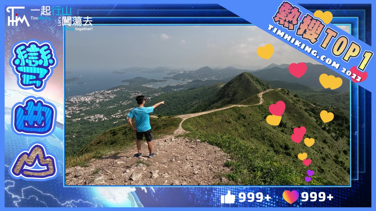
Wan Kuk Shan
View : Difficulty : Path : Shui Long Wo ➡ Star Lookout ➡ MacLehose Trail (Section 4) ➡ Shui L… Length : 10.4 km Time : 4.5 hours Wan Kuk Shan is 592 meters high, located between Ma On Shan and Pyramid Hill, with MacLehose Trail besides. Its mountain…
Total Views: 484,236
West Buffalo Hill,
Buffalo Hill,
West Buffalo Stone CityView : Difficulty : Skip Stone CityPath : Wong Nai Tau ➡ Fa Sam Hang ➡ Shek Nga Pui ➡ West Buffalo Hill ➡ We… Length : 6.8 km Time : 4 hours West Buffalo Hill, Buffalo Hill is located between Shatin and Sai Kung, connecting with Shek Nga Shan, forming a ridge. …
Total Views: 467,155
Kai Kung Leng,
Kai Kung ShanView : Difficulty : Path : Fung Kat Heung ➡ Kai Kung Shan ➡ Ngo Tau Rock ➡ Fairy Dressing Roc… Length : 6.6 km Time : 3 hours Kai Kung Leng is a mountain ridge located within the Lam Tsuen Country Park. It includes Tai Lo Tin (572m), Lo Tin Teng …
Total Views: 465,993
Sze Shan,
Middle Hill,
Fu ShanView : Difficulty : Path : Ling Yan Temple Bus Stop ➡ Sze Shan ➡ Hen Rock ➡ Middle Hill ➡ Pup… Length : 7.5 km Time : 5.5 hours Sze Shan and Middle Hill are located on the east side of Tai O, Lantau Island. According to legend, Fu Shan and Feng Sha…
Total Views: 180,935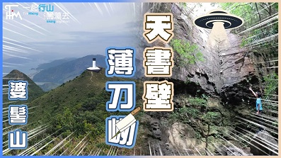
Po To Yan,
Heavenly Book Wall,
Por Kai ShanView : 
Difficulty : Path : Ma Wan New Village ➡ Wong Tung Hang Road ➡ Siu Chi Fung ➡ Tung Sam… Length : 8.2 km Time : 5 hours Po To Yan is located in the southeast of Tung Chung, Lantau Island, with a high altitude of 529 meters. Heavenly Book Wa…
Total Views: 253,124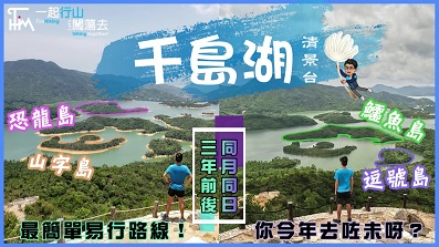
Tai Lam Chung Reservoir,
Wong Nai Chung ReservoirView : Difficulty : Path : So Kwun Wat ➡ So Kwun Wat Tsuen Road ➡ MacLehose Trail (Section 10… Length : 8.2 km Time : 3 hours Reservoir Islands Viewpoint was completed in early 2019. It is the best official place to view Tai Lam Chung Reservoir. …
Total Views: 500,433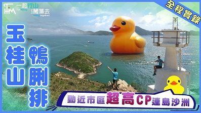
Yuk Kwai Shan,
Ap Lei PaiView : Difficulty : edge climbing return to the starting pointPath : Lei Tung Station ➡ Yuk Kwai Shan ➡ Tombolo ➡ Ap Lei Pai ➡ Lighthou… Length : 4.4 km Time : 3.5 hours Yuk Kwai Shan is 196 meters high which is the highest mountain in Ap Lei Chau and located in the south of Lei Tung Estat…
Total Views: 364,546
And all things, whatsoever ye shall ask in prayer, believing, ye shall receive.
Matthew 21:22
Today's History

Kunpeng Trail (Section 12) MeiShanJian Daguzhang
View : Difficulty : Path : Tansian Temple ➡ Zhangding ➡ MeiShanJian ➡ The Gengzi Uprising Scu… Length : 19.69 km Time : 12.5 hours The name Kunpeng Trail comes from the legendary mythical beasts. Kun is a mythical fish, which is thousands of miles lon…
Total Views: 19,015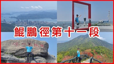
Kunpeng Trail (Section 11) Wutong Mountain
View : Difficulty : Path : Wangtong Xin Road Hiking Trail Entrance ➡ Small WuTongThe TV Tower… Length : 13 km Time : 7 hours The name Kunpeng Trail comes from the legendary mythical beasts. Kun is a mythical fish, which is thousands of miles lon…
Total Views: 16,485
Shenzhen Dadingling,
GuangMing Threee Bridges,
Rainbow BridgeView : Difficulty : Path : GuangMing Smooth Grass Park ➡ ShenzhenDadingling Greenway ➡ Dading… Length : 9.9 km Time : 4.5 hours In addition to the famous GuangMing pigeons in GuangMing District, Shenzhen, there are also two famous parks, Dadingling…
Total Views: 72,886
Checkerboard Hill
View : Difficulty : 
Path : Lok Fu Station ➡ Lok Fu Park ➡ Checkerboard Hill Path ➡ Checkerboa… Length : 2.6 km Time : 1.5 hours Checkerboard Hill is also known as Radar Hill or Lok Fu Shan. It is 98 meters high and located in Kowloon Tsai, a small …
Total Views: 146,294
Mount Kellett,
Mount Gough,
Victoria PeakView : Difficulty : not visit Trigonometrical StationPath : Mount Kellett Road ➡ Mount Kellett ➡ Mount Gough ➡ Peak Galleria ➡… Length : 8 km Time : 2.5 hours Mount Kellett, is 501 meters high, the third highest peak on Hong Kong Island, and the 47th highest in Hong Kong. Mount …
Total Views: 104,619
Shan Tseung Fat Trig-Station
View : Difficulty : Path : Sham Tseng ➡ Sham Tseng East Village ➡ Lamp Post V9320 ➡ Old Trig… Length : 1.7 km Time : 1 hours The Trigonometrical Station 4010.23 is the fattest trigonometrical station in Hong Kong. It is located on the hill betwe…
Total Views: 67,684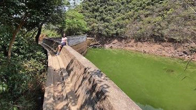
Ngau Wu Reservoir
View : 
Difficulty : BacktrackPath : Kam Ying Court ➡ Ngau Wu Reservoir ➡ Ma Mei Rridge ➡ Ma On Shan By… Length : 2.7 km Time : 1.25 hours Ngau Wu Reservoir is located at the lower reaches of Ngau Wu Stream in Ma On Shan. It was originally a private storage w…
Total Views: 42,214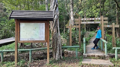
Tsuen Kam Nature Trail
View : Difficulty : Path : Tsuen Kam Au ➡ Fa Shan Tau ➡ Tsuen Kam Campsite ➡ Tsuen Kam Nature… Length : 1.8 km Time : 1 hours Tsuen Kam Nature Trail is located in Tai Lam Forest Track (Twisk Section). The starting point is the same as the ending …
Total Views: 46,402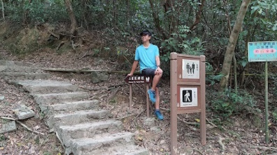
Sheung Yiu Family Trail
View : 
Difficulty : Path : Pak Tam Chung Nature Trail ➡ Sheung Yiu Family Trail ➡ Tai Mong Ts… Length : 1.7 km Time : 0.5 hours Sheung Yiu Family Trail is one of the two main official dirt trails to and from Sheung Yiu. You can take a route to Tai …
Total Views: 37,292
The Lord is not slow in keeping his word, as he seems to some, but he is waiting in mercy for you, not desiring the destruction of any, but that all may be turned from their evil ways.
2 Peter 3:9 BBE
Random Routes
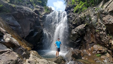
Wang Chung Stream
View : Difficulty : Path : Bride's Pool ➡ Wang Chung Stream ➡ Triangle Falls ➡ Lung Chu Falls… Length : 3 km Time : 2.5 hours Wang Chung Stream is one of the nine largest streams in Hong Kong. It is located north of Pat Sin Leng and is a downstre…
Total Views: 55,809
Wilson Trail (Section 3)
View : Difficulty : Path : Lam Tin Station ➡ Lei Yue Mun Road ➡ Ko Chiu Road ➡ Devil's Peak M… Length : 9.2 km Time : 4 hours Wilson Trail (Section 3) is the third longest section of the 10 Sections. From Section 2 to Section 3, it is the only se…
Total Views: 122,451
Lam Chung,
Kwai Tau Leng,
Princess HillView : Difficulty : Path : Lam Chung ➡ Lam Chung Country Trail ➡ Kwai Tau Leng ➡ Princess Hil… Length : 7.1 km Time : 4.5 hours The elevation of Kwai Tau Leng and Princess Hill is 486 meters and 118 meters respectively. Kwai Tau Leng is located dir…
Total Views: 49,567
Wilson Trail (Section 2)
View : Difficulty : Path : Wong Nai Chung Reservoir ➡ Jardine's Lookout ➡ Siu Ma Shan ➡ Mount… Length : 6.8 km Time : 2.5 hours Wilson Trail (Section 2) is located on Hong Kong Island, starting from Wong Nai Chung Reservoir and Hong Kong Parkview. …
Total Views: 109,852
God Eagle Rock,
Kung Um ShanView : Difficulty : Path : Chung Uk Tsuen ➡ Wo Ping San Tsuen ➡ Hung Shui Hang ➡ Hung Shui Ha… Length : 7.2 km Time : 4 hours Kung Um Shan, also known as Mount 297, has an altitude of 297 meters. It is located in the northwestern part of the New …
Total Views: 109,892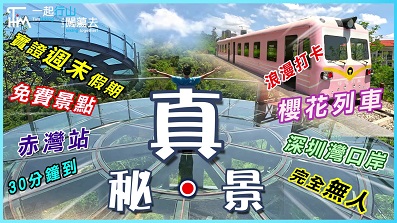
Shenzhen Xiaonan Shan,
Chiwan Cherry GardenView : Difficulty : Path : Chiwan Station ➡ Gangwan Living Area ➡ Chiwan Cherry Garden ➡ Cher… Length : 4.9 km Time : 2 hours Xiaonan Shan, 287 meters high, located in Xiaonan Shan Garden in Chiwan, Nam Shan District, Shenzhen. Overlooking Shekou…
Total Views: 42,053
Fung Hang Family Trail
View : Difficulty : Path : Kai Kuk Shue Ha ➡ Fung Hang Family Trail (Wu Tung Shan) Viewing Po… Length : 2 km Time : 0.75 hours Fung Hang Family Trail is located in Luk Keng, New Territories, near Sha Tau Kok Hoi. The official length is 2.25km and …
Total Views: 38,067Shenzhen Ten Peaks Dabijiashan
View : Difficulty : Path : Baishawan Park ➡ Sanganbi ➡ Hankeng Rest Area ➡ Dabijiashan ➡ Hank… Length : 8.2 km Time : 5.5 hours Shenzhen Dabijiashan is 717 meters above sea level. It is located in Baguang, east of Shenzhen, at the junction of Shenz…
Total Views: 21,613Sheung Yiu Family Trail
View : Difficulty : Path : Pak Tam Chung Nature Trail ➡ Sheung Yiu Family Trail ➡ Tai Mong Ts… Length : 1.7 km Time : 0.5 hours Sheung Yiu Family Trail is one of the two main official dirt trails to and from Sheung Yiu. You can take a route to Tai …
Total Views: 37,292
The LORD lifteth up the meek: he casteth the wicked down to the ground.
Psalms 147:6